|
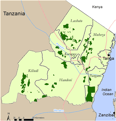
TANZANIA - TANGA REGION
Districts in Tanga Region
Click on a District on the map, or follow the text links below.
Handeni
Korogwe
Muheza
Pangani
Tanga Municipality
Handeni District
In the Handeni District there are 9 coastal forested areas profiled. These are listed below:
In addition, there are 2 forests within the district that have no available information and are not given as forest profiles:
- Bondo Forest 328 ha
- Magambazi Forest 750 ha
There is one Important Bird Area found in GendaGenda North and South and Mtunguru Forest Reserves (TZ IBA 54).
Conservation Initiatives:
Key Economic and hydrological values:
Back to Region index
Handeni - Genda Genda North Forest Reserve
Reserve name: Genda Genda North Forest Reserve
Description: Dry lowland forest, riverine forest, scrub forest, thicket, woodland and grassland between 20 - 220m asl
Location: 5° 26’ S – 5° 26’ S; 38° 38’ E – 38° 40’ E
Closest settlements: 8km from Genda Genda, 100 km from Handeni
Area: 891 ha
More details
Threats: Bisection of reserve by Muheza railway, fires, cultivation, logging.
Conservation initiatives: Central Government Protective Reserve.
Conservation designations: Part ofHandeni District Coastal Forests IBA 54
References: Baker, N.E. and Baker, E. M. (2002). Important Bird Areas in Tanzania: A first inventory. Wildlife Conservation Society of Tanzania, Dar es Salaam, Tanzania
Clarke, G.P. and Stubblefield, L.K. (1995). Status Reports for 7 Coastal Forests in Tanga Region, Tanzania. Frontier-Tanzania Technical Report No. 16. The Society for Environmental Exploration, U.K. / The University of Dar es Salaam, Tanzania
Critical Ecosystem Partnership Fund (CEPF) (2005). Eastern Arc Mountains and Coastal Forests of Tanzania and Kenya. Ecosystem Profile (updated in March 2005). (pdf)
Lovett, J.C. and Pócs, T. (1993). Assessment of the Condition of the Catchment Forest Reserves, a botanical appraisal. Catchment Forestry Report 93.3. The Catchment Forestry Project, Forestry and Beekeeping Division, DSM, Tz. 111-112
Back to District index | Back to Region index
Handeni - Genda Genda South Forest Reserve
 Reserve name: Genda Genda South Forest Reserve Reserve name: Genda Genda South Forest Reserve
Description: Dry lowland forest, riverine forest, scrub forest, thicket, woodland and grassland between 120 - 525m asl
Location: 5° 27’ S – 5° 30’ S; 38° 37’ E - 38° 39’ E
Closest settlements: 1 km from Genda Genda village. 20 km from Mumbwi,
90 km from Handeni,
Area: 1910 ha
More details
Threats: Historically logging with extensive damage from charcoal production and limited pole and timber extraction, fire, some encroachment for cultivation
Conservation initiatives: Central Government Protective Reserve.
Conservation designations: Part of Handeni District Coastal Forests IBA 54
References: Baker, N.E. and Baker, E. M. (2002). Important Bird Areas in Tanzania: A first inventory. Wildlife Conservation Society of Tanzania, Dar es Salaam, Tanzania
Clarke, G.P. and Stubblefield, L.K. (1995). Status Reports for 7 Coastal Forests in Tanga Region, Tanzania. Frontier-Tanzania Technical Report No. 16. The Society for Environmental Exploration, U.K. / The University of Dar es Salaam, Tanzania
Critical Ecosystem Partnership Fund (CEPF) (2005). Eastern Arc Mountains and Coastal Forests of Tanzania and Kenya. Ecosystem Profile (updated in March 2005). (pdf)
Hawthorne , W.D. (1984). Ecological and biogeographical patterns in the Coastal Forests of East Africa. Unpublished PhD thesis, University of Oxford.
Lovett, J.C. and Pócs, T. (1993). Assessment of the Condition of the Catchment Forest Reserves, a botanical appraisal. Catchment Forestry Report 93.3. The Catchment Forestry Project, Forestry and Beekeeping Division, DSM, Tz. 113-114
Back to District index | Back to Region index
Handeni - Handeni Hill Forest Reserve
Reserve name: Handeni Hill Forest Reserve
Description: Woodland on the SW, W, and NW slopes; dry deciduous and evergreen lowland forest on the wetter NE, E, S and SE slopes between 790 - 1040m asl.
Location: 5° 27’ S; 38° 3’ E
Closest settlements: 2 km from Handeni
Area: 677 ha
More details
Threats: Deforestation and degradation on town side of reserve; logging on large scale for building poles (Brachylaena hiullensis); fire
Conservation initiatives: Central Government Protective Reserve.
Conservation designations:
References: Lovett, J.C. and Pócs, T. (1993). Assessment of the Condition of the Ca tchment Forest Reserves, a botanical appraisal. Catchment Forestry Report 93.3. The Catchment Forestry Project, Forestry and Beekeeping Division, DSM, Tz. 115-116
Back to District index | Back to Region index
Handeni - Kwasumba Forest Reserve
Reserve name: Kwasumba Forest Reserve
Description: Dry scrub forest between 580 - 640 m asl
Location: 5° 39’ S; 38° 03’ E
Closest settlements: Unknown
Area: 2933 ha
More details
Threats: Timber extractions, pole cutting, fires
Conservation initiatives:
Conservation designations:
References: Burgess, N. (2004). Coastal Forest sites table, May 2004. Document prepared for WWF East African Coastal Forest Ecoregion Programme, Nairobi, Kenya.
Back to District index | Back to Region index
Handeni - Mbuzini
Reserve name: Mbuzini
Description: Dry scrub forest
Location: 5° 38’ S; 38° 00’ E
Closest settlements: Unknown
Area: Unknown but 50 ha of forest remain
More details
Threats: Agriculture, charcoal, fire
Conservation initiatives: Public lands, no protection
Conservation designations:
References: Burgess, N. (2004). Coastal Forest sites table, May 2004. Document prepared for WWF East African Coastal Forest Ecoregion Programme, Nairobi, Kenya.
Back to District index | Back to Region index
Handeni - Mgambo
Reserve name: Mgambo
Description: Dry Scrub forest at 300 m asl
Location: 5° 32’ S; 38° 38’ E
Closest settlements: Unknown
Area: 2000 ha
More details
Threats: Agriculture, charcoal, fire
Conservation initiatives: Public lands, no protection
Conservation designations:
References: Burgess, N. (2004). Coastal Forest sites table, May 2004. Document prepared for WWF East African Coastal Forest Ecoregion Programme, Nairobi, Kenya.
Back to District index | Back to Region index
Handeni - Mkongo Catchment Forest Reserve
Reserve name: Mkongo Catchment Forest Reserve
Description: Woodland with some groundwater forest between 870 - 1130m asl
Location: 5° 27’ S - 5° 29’ S; 37° 33’ E
Closest settlements: 62 km from Handeni, 3 km from Kwediboma
Area: 985 ha
More details
Threats: Cutting, fires
Conservation initiatives: Central Government Protective Reserve
Conservation designations:
References: Burgess, N. (2004). Coastal Forest sites table, May 2004. Document prepared for WWF East African Coastal Forest Ecoregion Programme, Nairobi, Kenya.
Lovett, J.C. and Pócs, T. (1993). Assessment of the Condition of the Catchment Forest Reserves, a botanical appraisal. Catchment Forestry Report 93.3. The Catchment Forestry Project, Forestry and Beekeeping Division, DSM, Tz. 123-124
Back to District index | Back to Region index
Handeni - Mkuli Catchment Forest Reserve
Reserve name: Mkuli Catchment Forest Reserve
Description: Brachystegia woodland and dry submontane forest between 780 – 1260 m asl
Location: 5° 47’ S; 37° 28’ E
Closest settlements: Neighbouring villages: Tamota and Vyadigwa
Area: 2931 ha
More details
Threats: Logging with fire in the woodlands
Conservation initiatives: Central Government Protective Reserve
Conservation designations:
References: Burgess, N. (2004). Coastal Forest sites table, May 2004. Document prepared for WWF East African Coastal Forest Ecoregion Programme, Nairobi, Kenya.
Lovett, J.C. and Pócs, T. (1993). Assessment of the Condition of the Cacthment Forest Reserves, a botanical appraisal. Catchment Forestry Report 93.3. The Catchment Forestry Project, Forestry and Beekeeping Division, DSM, Tz. 125-126
Back to District index | Back to Region index
Handeni - Mtunguru Forest Reserve
Reserve name: Mtunguru Forest Reserve
Description: Dry woodland and scrub between 580 – 760 m asl
Location: 5° 36’ S; 38° 05’ E
Closest settlements: Neighbouring villages: Handeni and Mkata
Area: 2305 ha
More details
Threats: Logging
Conservation initiatives: District Authority Forest Reserve
Conservation designations: Part of Handeni District Coastal Forests IBA 54
References: Baker, N.E. and Baker, E. M. (2002). Important Bird Areas in Tanzania: A first inventory. Wildlife Conservation Society of Tanzania, Dar es Salaam, Tanzania
Critical Ecosystem Partnership Fund (CEPF) (2005). Eastern Arc Mountains and Coastal Forests of Tanzania and Kenya. Ecosystem Profile (updated in March 2005). (pdf)
Back to District index | Back to Region index
Korogwe District
In Korogwe District there are 2 coastal forested areas profiled. These are listed below:
There are no Important Bird Areas found in this district.
Conservation Initiatives: The East Usambara Conservation Area Management Programme (1990-2002), implemented by Forestry and Beekeeping Division of the Ministry of Natural Resource and Tourism, Tanzania with support from the Government of Finland, worked in selected forest reserves to protect their water source and biodiversity values.
Key Economic and hydrological values: The East Usambaras are the major water catchment area for the Sigi River providing over 200,000 people with their water supply.
Back to Region index
Korogwe - Bombo West Forest Reserve
Reserve name: Bombo West Forest Reserve
Description: Woodland and thicket between 380 – 680 m asl
Location: 4° 47’ S - 4° 52’ S; 38° 39’ E - 38° 43’ E
Closest settlements: 6 km from Mashewa
Area: 3523 ha
More details
Threats: Logging, grazing, fuelwood collection
Conservation initiatives: Central Government Protective Reserve
Conservation designations:
References: Lovett, J.C. and Pócs, T. (1993). Assessment of the Condition of the Catchment Forest Reserves, a botanical appraisal. Catchment Forestry Report 93.3. The Catchment Forestry Project, Forestry and Beekeeping Division, DSM, Tz. 135-136
Back to District index | Back to Region index
Korogwe - Mafi Hill Forest Reserve
Reserve name: Mafi Hill Forest Reserve
Description: Dry secondary thicket, woodland and dry lowland forest between 600 – 1480 m asl
Location: 4° 53’ S - 4° 57’ S; 38° 06’ E - 38° 11’ E
Closest settlements: 14 km from Mazinde; 20 km from Mombo
Area: 4508 ha
More details
Threats: Pole cutting, hunting hyrax
Conservation initiatives: Central Government Protective Reserve. Joint forest management has been established in this reserve with support from the NORAD financed Catchment Forest Project.
Conservation designations:
References: Lovett, J.C. and Pócs, T. (1993). Assessment of the Condition of the Catchment Forest Reserves, a botanical appraisal. Catchment Forestry Report 93.3. The Catchment Forestry Project, Forestry and Beekeeping Division, DSM, Tz. 141-142
Back to District index | Back to Region index
Muheza District
In the Muheza District there are 16 coastal forested areas. Many of these are lowland Eastern Arc forests, which have a small proportion of coastal forest within the reserve. These are listed below:
In addition, there are 2 forests within the district that have no available information and are not given as forest profiles:
- Bassi Forest 1197 ha cleared for exotics
- Gombero Forest 2399 ha cleared for agriculture
There is two Important Bird Areas found in the Muheza Coastal Forests. The first includes Kilulu Hill Forest, Kwani Forest Reserve, Pangani Falls Forest and Tongwe Forest Reserve (TZ IBA 55). The second includes some of the lowland Usambara forests including Manga, Kambai, Seboma, Bamba Ridge and Longuza Forest Reserves (TZ IBA 70).
Conservation Initiatives: The East Usambara Conservation Area Management Programme (1990-2002), implemented by Forestry and Beekeeping Division of the Ministry of Natural Resource and Tourism, Tanzania with support from the Government of Finland, worked in selected forest reserve to protect their water source and biodiversity values. Since 1993, the Tanzania Forest Conservation Group have supported community based forest conservation around Kambai and more recently around Manga, Semdoe, Segoma and Longuza.
Key Economic and hydrological values: The East Usambaras are the major water catchment area for the Sigi River providing over 200,000 people with their water supply.
Back to Region index
Muheza - Bamba Ridge
Reserve name: Bamba Ridge
Description: Lowland and submontane forest between 150 – 1033 m asl.
Location: 38o47’E 4o58’S
Closest settlements: Segoma Village
Area: 1131 ha
More details
Threats: Fire, logging.
Conservation initiatives: Central Government Protective Reserve
Conservation designations: Important Bird Area
References: Frontier Tanzania, 1996. Bamba Ridge Forest Reserve: a biodiversity survey. East Usambara Conservation Area Management Programme Technical Paper No. 31. Frontier Tanzania; Forestry and Beekeeping Division, Dar es Salaam, Tanzania and Indufor / Metsähallitus Group, Vantaa, Finland. 88pp
Back to District index | Back to Region index
Muheza - Bombo East I Forest Reserve
Reserve name: Bombo East I Forest Reserve
Description: Degraded lowland forest between 220 – 620 m asl
Location: 4° 48’ S - 4° 50’ S; 38° 42’ E - 38° 43’ E
Closest settlements: Neighbouring villages: Makorokoro, Nnazi Moja and Bombo Maji Moto
Area: 448 ha
More details
Threats: Fire, logging
Conservation initiatives: Central Government Protective Reserve
Conservation designations:
References: Frontier Tanzania (2002). Staddon, S., Fanning, E and Howell, K.M. (eds.) (2002). Bombo East I Forest Reserve:a biodiversity survey. East Usambara Conservation Area Management Programme Technical Paper No. 57. Frontier Tanzania; Forestry and Beekeeping Division, Dar es Salaam, Tanzania and Indufor / Metsähallitus Group, Vantaa, Finland. 95pp
Back to District index | Back to Region index
Muheza - Bombo East II Forest Reserve
Reserve name: Bombo East II Forest Reserve
Description: Degraded lowland forest between 440 – 840 m asl
Location: 4° 43’ S - 4° 49’ S; 38° 39’ E - 38° 41’ E
Closest settlements: Neighbouring villages: Makorokoro, Nnazi Moja and Bombo Maji Moto
Area: 404 ha
More details
Threats: Fire, logging
Conservation initiatives: Central Government Protective Reserve
Conservation designations:
References: Frontier Tanzania (2002). Staddon, S., Fanning, E and Howell, K.M. (eds.) (2002). Bombo East II Forest Reserve:a biodiversity survey. East Usambara Conservation Area Management Programme Technical Paper No. 58. Frontier Tanzania; Forestry and Beekeeping Division, Dar es Salaam, Tanzania and Indufor / Metsähallitus Group, Vantaa, Finland. 88pp
Back to District index | Back to Region index
Muheza - Kilulu Hill Forest Reserve
 Reserve name: Kilulu Hill Forest Reserve name: Kilulu Hill Forest
Description: Dry forest and thicket between 200 - 267 m asl
Location: 4° 46’ S; 39° 07’ E
Closest settlements: 0.5 km from Kilulu village
Area: 160 ha
More details
Threats: Historically intensive logging. Fuelwood collection, hunting, cultivation, fire, wood for carvings
Conservation initiatives: Proposed Forest Reserve
Conservation designations: Part of Muheza District Coastal Forests IBA 55
References: Baker, N.E. and Baker, E. M. (2002). Important Bird Areas in Tanzania: A first inventory. Wildlife Conservation Society of Tanzania, Dar es Salaam, Tanzania
Clarke, G.P. and Stubblefield, L.K. (1995). Status Reports for 7 Coastal Forests in Tanga Region, Tanzania. Frontier-Tanzania Technical Report No. 16. The Society for Environmental Exploration, U.K. / The University of Dar es Salaam, Tanzania
Critical Ecosystem Partnership Fund (CEPF) (2005). Eastern Arc Mountains and Coastal Forests of Tanzania and Kenya. Ecosystem Profile (updated in March 2005). (pdf)
Back to District index | Back to Region index
Muheza - Kambai Forest Reserve
Reserve name: Kambai Forest Reserve
Description: Lowland forest, bushland and cultivation between 200 – 870 m asl
Location: 5° 00’ S; 38° 42’ E
Closest settlements:
Area: 1046.3 ha
More details
Threats: pole and timber cutting
Conservation initiatives: National Forest Reserve?
Conservation designations:
References: Cunneyworth, P. (1996). Kambai Forest Reserve: a biodiversity survey. East Usambara Conservation Area Management Programme Technical Paper No. 35. Frontier Tanzania; Forestry and Beekeeping Division, Dar es Salaam, Tanzania and Indufor / Metsähallitus Group, Vantaa, Finland. 107pp
Back to District index | Back to Region index
Muheza - Kwamarimba Forest Reserve
Reserve name: Kwamarimba Forest Reserve
Description: Dry lowland forest and evergreen lowland forest between 95 – 445 m asl
Location: 5° 02’ S; 38° 45’ E
Closest settlements:
Area: 887.4 ha
More details
Threats: fire, pitsawing, hunting
Conservation initiatives: National Forest Reserve?
Conservation designations:
References: Cunneyworth, P. (1996). Kwamarimba Forest Reserve: a biodiversity survey. East Usambara Conservation Area Management Programme Technical Paper No. 33. Frontier Tanzania; Forestry and Beekeeping Division, Dar es Salaam, Tanzania and Indufor / Metsähallitus Group, Vantaa, Finland. 104pp
Back to District index | Back to Region index
Muheza - Kwamgumi Forest Reserve
 Reserve name: Kwamgumi Forest Reserve Reserve name: Kwamgumi Forest Reserve
Description: Lowland forest, submontane forest and cultivation between 150 – 915 m asl
Location: 4° 55’ S - 4° 57’ S; 38° 44’ E -; 38° 47’ E
Closest settlements: Kwamtili village
Area: 1128.8 ha
More details
Threats: Pole cutting, fire, trapping
Conservation initiatives: National Forest Reserve?
Conservation designations:
References: Doggart, N., Dilger, M.S., Cunneyworth, P. and Fanning, E. (1999). Kwamgumi Forest Reserve: a biodiversity survey. East Usambara Conservation Area
Management Programme Technical Paper No. 40. Frontier Tanzania; Forestry and Beekeeping Division, Dar es Salaam, Tanzania and Indufor / Metsähallitus Group, Vantaa, Finland. 90pp
Back to District index | Back to Region index
Muheza - Kwani Forest Reserve
Reserve name: Kwani Forest Reserve (near to Pangani Falls forest)
Description: Small part of hill top evergreen forest, woodland and grassland between 0 - 200 m asl
Location: 5° 21’ S; 38° 41’ E
Closest settlements:
Area: 2545 ha
More details
Threats: Fire
Conservation initiatives: Part of JFM, now well protected
Conservation designations: Part of Muheza District Coastal Forests IBA 55
References: Baker, N.E. and Baker, E. M. (2002). Important Bird Areas in Tanzania: A first inventory. Wildlife Conservation Society of Tanzania, Dar es Salaam, Tanzania
Burgess, N. (2004). Coastal Forest sites table, May 2004. Document prepared for WWF East African Coastal Forest Ecoregion Programme, Nairobi, Kenya.
Clarke, G.P. and Stubblefield, L.K. (1995). Status Reports for 7 Coastal Forests in Tanga Region, Tanzania. Frontier-Tanzania Technical Report No. 16. The Society for Environmental Exploration, U.K. / The University of Dar es Salaam, Tanzania
Critical Ecosystem Partnership Fund (CEPF) (2005). Eastern Arc Mountains and Coastal Forests of Tanzania and Kenya. Ecosystem Profile (updated in March 2005). (pdf)
Back to District index | Back to Region index
Muheza - Longuza Forest Reserve
Reserve name: Longuza Forest Reserve
Description: Teak plantation, lowland forest, woodland, thicket, cultivation and settlement at 95 – 345 m asl
Location: 5° 02’ S; 38° 41’ E
Closest settlements:
Area: 1579.9 ha
More details
Threats: Pole cutting, logging, fire
Conservation initiatives: National Forest Reserve
Conservation designations:
References: Cunneyworth, P. (1996). Longuza (North)Forest Reserve: a biodiversity survey. East Usambara Conservation Area Management Programme Technical Paper No. 34. Frontier Tanzania; Forestry and Beekeeping Division, Dar es Salaam, Tanzania and Indufor / Metsähallitus Group, Vantaa, Finland. 72pp
Back to District index | Back to Region index
Muheza - Manga Forest Reserve
Reserve name: Manga Forest Reserve
Description: Lowland forest between 120 – 360 m asl
Location: 5° 00’ S - 5° 02’ S; 38° 45’ E - 38° 47’ E
Closest settlements: Neighbouring villages: Mkwajuni, Misozwe, Kwatango and Segoma
Area: 1635 ha
More details
Threats: Cultivation, pole and timber cutting, fire
Conservation initiatives: Central Government Protective Reserve
Conservation designations:
References: Doggart, N., Joseph, L., Bayliss, J. and Fanning, E. (1999). Manga Forest Reserve: a biodiversity survey. East Usambara Conservation Area Management Programme Technical Paper No. 41. Forestry and Beekeeping Division, Finnish Forest and Park Service and the Society for Environmental Exploration, Dar es Salaam, Vantaa and London. 92pp.
Back to District index | Back to Region index
Muheza - Mgambo Forest Reserve
Reserve name: Mgambo Forest Reserve
Description: Forest and cultivation between 320 – 820 m asl
Location: 4° 44’ S - 4° 47’ S; 38° 47’ E - 38° 49’ E
Closest settlements: Neighbouring villages: Bwiti, Kwajanga, Mgambo, Kibaoni and Daluni
Area: 1346 ha
More details
Threats: Cultivation, fire, pit sawing, pole cutting
Conservation initiatives: Central Government Protective Reserve
Conservation designations:
References: Frontier Tanzania (2002). Oliver, S.A., Bracebridge, C.E., Fanning, E. and Howell, K.M. (eds.) (2002). Mgambo Forest Reserve: a biodiversity survey. East Usambara Conservation Area Management Programme Technical Paper No. 59. Frontier Tanzania; Forestry and Beekeeping Division, Dar es Salaam, Tanzania and Indufor / Metsähallitus Group, Vantaa, Finland. 99pp
Back to District index | Back to Region index
Muheza - Mlinga Forest Reserve
Reserve name: Mlinga Forest Reserve
Description: Lowland forest and submontane forest with cultivation between 220 – 1069 m asl
Location: 5° 04’ S - 5° 05’ S; 38° 44’ E - 38° 46’ E
Closest settlements: Neighbouring villages: Misozwe, Magula and Mwembeni
Area: 890 ha
More details
Threats: Cultivation, fire, pit sawing, pole cutting
Conservation initiatives: Central Government Protective Reserve
Conservation designations:
References: Frontier Tanzania (2002). Hall, S.M., Fanning, E., Howell, K.M. and Pohjonen, V (eds.) (2002). Mlinga Forest Reserve: a biodiversity survey. East Usambara Conservation Area Management Programme Technical Paper No. 56. Frontier Tanzania; Forestry and Beekeeping Division, Dar es Salaam, Tanzania and Indufor / Metsähallitus Group, Vantaa, Finland. 110pp
Back to District index | Back to Region index
Muheza - Mlungui Forest Reserve
Reserve name: Mlungui Proposed Forest Reserve
Description: Forest and cultivation between 220 – 480 m asl
Location: 5° 00’ S; 38° 42’ E
Closest settlements:
Area: 200 ha
More details
Threats: Pole cutting
Conservation initiatives:
Conservation designations:
References: Cunneyworth, P and Stubblefield, L (eds.) (1996). Mlungui Proposed Forest Reserve: a biodiversity survey. East Usambara Conservation Area Management Programme Technical Paper No. 32. Frontier Tanzania; Forestry and Beekeeping Division, Dar es Salaam, Tanzania and Indufor / Metsähallitus Group, Vantaa, Finland. 72pp
Back to District index | Back to Region index
Muheza - Pangani Falls Forest
Reserve name: Pangani Falls Forest
Description: Dry evergreen forest and riverine forest between 20 - 160 m asl
Location: 5° 20’ S - 5° 21’ S; 38° 39’ E - 38° 40’ E
Closest settlements: 2 km W of Bwitini Darajani village 5 km SE from Hale town
Area: 100 ha
More details
Threats: Expansion of hydroelectric dam at Pangani Falls, agriculture, fire, some pole cutting, wood for carvings
Conservation initiatives: Government land with no formal protection
Conservation designations: Part of Muheza District Coastal Forests IBA 55
References: Baker, N.E. and Baker, E. M. (2002). Important Bird Areas in Tanzania: A first inventory. Wildlife Conservation Society of Tanzania, Dar es Salaam, Tanzania
Burgess, N. (2004). Coastal Forest sites table, May 2004. Document prepared for WWF East African Coastal Forest Ecoregion Programme, Nairobi, Kenya.
Clarke, G.P. and Stubblefield, L.K. (1995). Status Reports for 7 Coastal Forests in Tanga Region, Tanzania. Frontier-Tanzania Technical Report No. 16. The Society for Environmental Exploration, U.K. / The University of Dar es Salaam, Tanzania
Critical Ecosystem Partnership Fund (CEPF) (2005). Eastern Arc Mountains and Coastal Forests of Tanzania and Kenya. Ecosystem Profile (updated in March 2005). (pdf)
Back to District index | Back to Region index
Muheza - Segoma Forest Reserve
Reserve name: Segoma Forest Reserve
Description: Lowland forest and submontane forest with cultivation between 80 – 920 m asl
Location: 4° 57’ S - 5° 01’ S; 38° 43’ E - 38° 47’ E
Closest settlements: Segoma village
Area: 1168.2 ha (with proposed extension 1933.8 ha)
More details
Threats: Cultivation, fire, pit sawing
Conservation initiatives: Central Government Protective Reserve
Conservation designations:
References: Doody, K.Z., Howell, K.M. and Fanning, E.F. (eds.) (2001). Segoma Forest Reserve: a biodiversity survey. East Usambara Conservation Area Management Programme Technical Paper No. 50. Forestry and Beekeeping Division, Finnish Forest and Park Service and the Society for Environmental Exploration, Dar es Salaam, Vantaa and London. 90pp.
Back to District index | Back to Region index
Muheza - Tongwe Forest Reserve
Reserve name: Tongwe Forest Reserve
Description: Lowland forest, woodland and grassland between 220 - 648 m asl
Location: 5° 17’ S - 5° 19’ S; 38° 43’ E - 38° 45’ E
Closest settlements: 2 km from Kwabada village
Area: 1202 ha
More details
Threats: Logging, cultivation, fire, charcoal, wood for carvings, salt
Conservation initiatives: Central Government Protective Reserve. To be joined with Kwani FR proposal
Conservation designations: Part of Muheza District Coastal Forests IBA 55
References: Baker, N.E. and Baker, E. M. (2002). Important Bird Areas in Tanzania: A first inventory. Wildlife Conservation Society of Tanzania, Dar es Salaam, Tanzania
Burgess, N. (2004). Coastal Forest sites table, May 2004. Document prepared for WWF East African Coastal Forest Ecoregion Programme, Nairobi, Kenya.
Clarke, G.P. and Stubblefield, L.K. (1995). Status Reports for 7 Coastal Forests in Tanga Region, Tanzania. Frontier-Tanzania Technical Report No. 16. The Society for Environmental Exploration, U.K. / The University of Dar es Salaam, Tanzania
Critical Ecosystem Partnership Fund (CEPF) (2005). Eastern Arc Mountains and Coastal Forests of Tanzania and Kenya. Ecosystem Profile (updated in March 2005). (pdf)
Back to District index | Back to Region index
Pangani District
In the Pangani District there are 3 coastal forested areas profiled. These are listed below:
There is one Important Bird Area found in Msumbugwe Forest Reserve (TZ IBA 56).
Conservation Initiatives:
Key Economic and hydrological values:
Back to Region index
Pangani - Garafuno Forest Reserve
Reserve name: Garafuno Forest Reserve (now incorporated into Msumbugwe FR) (shared with Handeni District)
Description:
Location:
Closest settlements:
Area: 195 ha
More details
Threats:
Conservation initiatives:
Conservation designations:
References: Baker, N.E. and Baker, E. M. (2002). Important Bird Areas in Tanzania: A first inventory. Wildlife Conservation Society of Tanzania, Dar es Salaam, Tanzania
Back to District index | Back to Region index
Pangani - Msumbugwe Forest Reserve
 Reserve name: Msumbugwe Forest Reserve Reserve name: Msumbugwe Forest Reserve
Description: Dry forest, grassland and thicket between 80 - 120 m asl
Location: 5 5 27’ S - 5° 34’ S; 38° 43’ E – 38° 48’ E
Closest settlements: 5 km from Mtango village
Area: 4407 ha
More details
Threats: Logging, hunting, fires, fuelwood collection
 Conservation initiatives: Central Government Protective Reserve. Proposed to join to Saadani National Park as a migratory corridor by WWF Conservation initiatives: Central Government Protective Reserve. Proposed to join to Saadani National Park as a migratory corridor by WWF
Conservation designations: Part of Pangani District Coastal Forests IBA 56
References: Baker, N.E. and Baker, E. M. (2002). Important Bird Areas in Tanzania: A first inventory. Wildlife Conservation Society of Tanzania, Dar es Salaam, Tanzania
Burgess, N. (2004). Coastal Forest sites table, May 2004. Document prepared for WWF East African Coastal Forest Ecoregion Programme, Nairobi, Kenya.
Clarke, G.P. and Stubblefield, L.K. (1995). Status Reports for 7 Coastal Forests in Tanga Region, Tanzania. Frontier-Tanzania Technical Report No. 16. The Society for Environmental Exploration, U.K. / The University of Dar es Salaam, Tanzania
Critical Ecosystem Partnership Fund (CEPF) (2005). Eastern Arc Mountains and Coastal Forests of Tanzania and Kenya. Ecosystem Profile (updated in March 2005). (pdf)
Back to District index | Back to Region index
Tanga Municipality
In the Tanga Municipality there is one coastal forested area profiled. This is:
Mkulumuzi Forest is a part of Important Bird Area 55.
In addition, there is one forest within the district that has no available information and is not given as a forest profile:
- Jasini Forest 117 ha productive
Conservation Initiatives:
Key Economic and hydrological values:
Back to Region index
Tanga - Mkulumuzi (including Amboni caves) Forest
Reserve name: Mkulumuzi (including Amboni caves) Forest
Description: Dry coastal forest, riverine forest, coastal scrub and thicket between 0 - 80 m asl
Location: 5° 04’ S - 5° 06’ S; 39° 00’ E – 39° 03’ E
Closest settlements: Neighbouring villages: Kiomoni and Amboni
Area: 350 ha
More details
Threats: Charcoal production, firewood removal, pole cutting, agriculture, pitsawing, limestone quarrying
Conservation initiatives: Government land under Central Government Control (Department of Antiquities) (Caves Conservation area) and under Municipal control (other areas)
Conservation designations: Amboni Caves Conservation Area (1954). Part of Muheza District Coastal Forests IBA 55
References: Baker, N.E. and Baker, E. M. (2002). Important Bird Areas in Tanzania: A first inventory. Wildlife Conservation Society of Tanzania, Dar es Salaam, Tanzania
Clarke, G.P. and Stubblefield, L.K. (1995). Status Reports for 7 Coastal Forests in Tanga Region, Tanzania. Frontier-Tanzania Technical Report No. 16. The Society for Environmental Exploration, U.K. / The University of Dar es Salaam, Tanzania
Critical Ecosystem Partnership Fund (CEPF) (2005). Eastern Arc Mountains and Coastal Forests of Tanzania and Kenya. Ecosystem Profile (updated in March 2005). (pdf)
Back to District index | Back to Region index
|