|
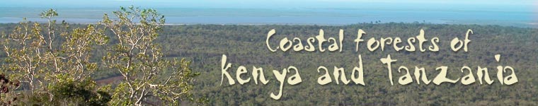
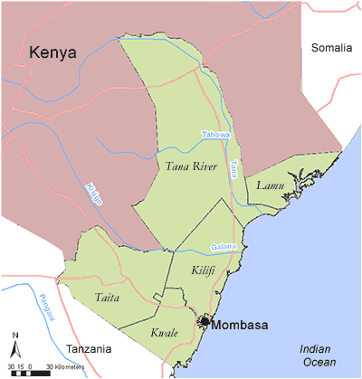
KENYA - COAST PROVINCE
Districts in Coast Province
Click on a District on the map, or follow the text links below.
Kilifi
Kwale
Kwale / Taita Taveta
Lamu District
Mombasa
Tana River
Tana River
In the Tana River District there are 6 coastal forested areas profiled. These are listed below:
There are two Important Bird Areas found in Mbia forests (IBA KE 22) and the Lower Tana River Forests (IBA KE 23).
Back to Province index
Tana River
Reserve name: Bura Gallery Forests (incl. Nanigi and Chewele)
Description: Forest at 60 m asl
Location: 01 ° 05’ S; 39° 55’ E
Closest settlements:
Area: 100 ha
More details
Threats: Not protected, resource use, agriculture, settlement
Conservation initiatives:
Conservation designations:
References: Burgess, N. (2004). Coastal Forest sites table, May 2004. Document prepared for WWF East African Coastal Forest Ecoregion Programme, Nairobi, Kenya.
Back to District index | Back to Province index
Tana River
Reserve name: Kanwe Mayi Forest fragments (5-7 patches)
Description: Forest at 10 m asl
Location: 02° 27’ S; 40° 28’ E
Closest settlements:
Area: 100 ha
More details
Threats: Not protected, resource use, agriculture, settlement
Conservation initiatives:
Conservation designations:
References: Burgess, N. (2004). Coastal Forest sites table, May 2004. Document prepared for WWF East African Coastal Forest Ecoregion Programme, Nairobi, Kenya.
Back to District index | Back to Province index
Tana River
Reserve name: Lower Tana River Forests
Description: Forest between 10 – 30 m asl
Location: 02° 10’ S - 02° 50’ S; 40° 10’ E - 40° 50’ E
Closest settlements: Unknown
Area: 60 000 ha
More details
Threats: Not protected, resource use, agriculture, settlement
Conservation initiatives:
Conservation designations: Part of Kenya IBA 23
References: BirdLife International (2005). BirdLife's online World Bird Database: the site for bird conservation. Version 2.0. Cambridge, UK. Available: www.birdlife.org
Critical Ecosystem Partnership Fund (CEPF) (2005). Eastern Arc Mountains and Coastal Forests of Tanzania and Kenya. Ecosystem Profile (updated in March 2005). (pdf)
Back to District index | Back to Province index
Tana River
Reserve name: Mbia
Description: Forest at 45 m asl
Location: 01° 37’ S; 40° 06’ E
Closest settlements: Unknown
Area: 100 ha
More details
Threats: Not protected, resource use, agriculture, settlement
Conservation initiatives:
Conservation designations:
References: Burgess, N. (2004). Coastal Forest sites table, May 2004. Document prepared for WWF East African Coastal Forest Ecoregion Programme, Nairobi, Kenya.
Back to District index | Back to Province index
Tana River
Reserve name: Tana River Delta
Description: Forest between 0 - 60 m asl
Location: 02° 50’ S; 40° 33’ E
Closest settlements: Unknown
Area: 130 000 ha
More details
Threats: Not protected, resource use, agriculture, settlement
Conservation initiatives:
Conservation designations: Part of Kenya IBA 22
References: BirdLife International (2005). BirdLife's online World Bird Database: the site for bird conservation. Version 2.0. Cambridge, UK. Available: www.birdlife.org
Burgess, N. (2004). Coastal Forest sites table, May 2004. Document prepared for WWF East African Coastal Forest Ecoregion Programme, Nairobi, Kenya.
Critical Ecosystem Partnership Fund (CEPF) (2005). Eastern Arc Mountains and Coastal Forests of Tanzania and Kenya. Ecosystem Profile (updated in March 2005). (pdf)
Back to District index | Back to Province index
Tana River
Reserve name: Tana River Nature Reserve(1975)
Description: Forest between 10 – 30 m asl
Location: 01° 43’ S; 40° 03’ E
Closest settlements: Unknown
Area: 17 100 ha
More details
Threats: Resource use, agriculture, settlement
Conservation initiatives:
Conservation designations:
References: Burgess, N. (2004). Coastal Forest sites table, May 2004. Document prepared for WWF East African Coastal Forest Ecoregion Programme, Nairobi, Kenya.
Back to District index | Back to Province index
Tana River
Reserve name: Wayu I, Wayu II, Wayu II and Kokani Proposed Forest Reserve
Description: Forest
Location:
Closest settlements: Unknown
Area: 11 200 ha
More details
Threats: Not protected, resource use, agriculture, settlement
Conservation initiatives:
Conservation designations:
References: Burgess, N. (2004). Coastal Forest sites table, May 2004. Document prepared for WWF East African Coastal Forest Ecoregion Programme, Nairobi, Kenya.
Back to District index | Back to Province index
Lamu District
In Lamu District there are 5 coastal forested areas profiled. These are listed below:
There are no Important Bird Areas.
Back to Province index
Lamu District
Reserve name: Boni Proposed Forest Reserve
Description: Woodland and bushland between 0 - 100 m asl
Location: 01° 40’ S - 01° 67’ S; 40° 51’ E - 41° 17’ E
Closest settlements: Unknown
Area: 184 666 ha
More details
Threats: Resource use, settlements, agriculture
Conservation initiatives:
Conservation designations:
References: Critical Ecosystem Partnership Fund (CEPF) (2005). Eastern Arc Mountains and Coastal Forests of Tanzania and Kenya. Ecosystem Profile (updated in March 2005). (pdf)
Back to District index | Back to Province index
Lamu District
Reserve name: Dodori Forest
Description:
Location: 01° 75’ S; 41° 50’ E
Closest settlements: Unknown
Area: Unknown
More details
Threats: Unknown
Conservation initiatives:
Conservation designations:
References: Critical Ecosystem Partnership Fund (CEPF) (2005). Eastern Arc Mountains and Coastal Forests of Tanzania and Kenya. Ecosystem Profile (updated in March 2005). (pdf)
Back to District index | Back to Province index
Lamu District
Reserve name: Lango ya Simba
Description: Unknown
Location: 02° 27’ S; 40° 22’ E
Closest settlements: Unknown
Area: Unknown
More details
Threats: Unknown
Conservation initiatives:
Conservation designations:
References: Critical Ecosystem Partnership Fund (CEPF) (2005). Eastern Arc Mountains and Coastal Forests of Tanzania and Kenya. Ecosystem Profile (updated in March 2005). (pdf)
Back to District index | Back to Province index
Lamu District
Reserve name: Lunghi Proposed Forest Reserve
Description: Woodland and bushland between 0 -20 m asl
Location: 01° 44’ S - 01° 67’ S; 40° 45’ E - 41° 67’ E
Closest settlements: Unknown
Area: 95 170 ha
More details
Threats: Resource use, settlement, agriculture
Conservation initiatives:
Conservation designations:
References: Critical Ecosystem Partnership Fund (CEPF) (2005). Eastern Arc Mountains and Coastal Forests of Tanzania and Kenya. Ecosystem Profile (updated in March 2005). (pdf)
Back to District index | Back to Province index
Lamu District
Reserve name: Witu Forest Reserve
Description: Forest between 10 – 20 m asl
Location: 02° 22’ S - 02° 37’ S; 40° 30’ E - 41° 50’ E
Closest settlements: Unknown
Area: 3937 ha
More details
Threats: Resource use, settlement, agriculture
Conservation initiatives:
Conservation designations:
References: Burgess, N. (2004). Coastal Forest sites table, May 2004. Document prepared for WWF East African Coastal Forest Ecoregion Programme, Nairobi, Kenya.
Critical Ecosystem Partnership Fund (CEPF) (2005). Eastern Arc Mountains and Coastal Forests of Tanzania and Kenya. Ecosystem Profile (updated in March 2005). (pdf)
Back to District index | Back to Province index
Kwale
In Kwale District there are 32 coastal forested areas. These are listed below:
- Buda Forest Reserve
- Buda Mafisini Forest Reserve
- Cha Simba Forests
- Chuna Forest
- Chuna Gallery Forest
- Diani Forest
- Dzombo Forest Reserve
- Gongoni Forest Reserve
- Kaya Forests (Kaya Dzombo, Kaya Gonja, Kaya Miungoni, Kaya Sega)
- Kaya Forests (Kaya Kinondo, Kaya Muhaka, Kaya Ukunda)
- Kaya Forests (Kaya Bombo, Kaya Tiwi, Kaya Waa)
- Kaya Forests (Kaya Gandini, Kaya Lunguma, Kaya Puma, Kaya Teleza)
- Kilibasi Hills
- Lunga Lunga Gallery Forest
- Marenji Forest
- Mkongani North Forest Reserve
- Mkongani West Forest Reserve
- Mrima Forest Reserve
- Msambweni
- Mwache Forest Reserve
- Mwaluganji Forest Reserve
- Nzovuni River Forests
- Pangani Forests
- Shimba Hills Nature Reserve
- Shimoni Forests
There are 5 Important Bird Areas found in Chuna Gallery Forests (KE 09), Kaya Waa Forest (KE 13), Marenji Forest (KE 17), Mrima Hill Forest (KE 18) and Shimba Hills Nature Reserve (KE 20).
Conservation Initiatives: Bamburi Cement Ltd with WWF are currently involved in a landscape restoration project in the Shimba Hills
Key Economic and hydrological values:
Back to Province index
Kwale
Reserve name: Buda Forest Reserve (and near Buda Forest Reserve 1)
Description: Unknown
Location: 04° 45’ S; 39° 40’ E
Closest settlements: Unknown
Area: Unknown
More details
Threats: Unknown
Conservation initiatives:
Conservation designations:
References: Critical Ecosystem Partnership Fund (CEPF) (2005). Eastern Arc Mountains and Coastal Forests of Tanzania and Kenya. Ecosystem Profile (updated in March 2005). (pdf)
Back to District index | Back to Province index
Kwale
Reserve name: Buda Mafisini Forest Reserve
Description: Forest between 70 – 80 m asl
Location: 04° 26’ S; 39° 23’ E
Closest settlements: Unknown
Area: 668 ha
More details
Threats: Resource use, settlements
Conservation initiatives:
Conservation designations:
References: Burgess, N. (2004). Coastal Forest sites table, May 2004. Document prepared for WWF East African Coastal Forest Ecoregion Programme, Nairobi, Kenya.
Back to District index | Back to Province index
Kwale
Reserve name: Cha Simba Forest
Description: Unknown
Location: 04° 23’ S; 39° 45’ E
Closest settlements: Unknown
Area: Unknown
More details
Threats: Unknown
Conservation initiatives:
Conservation designations:
References: Critical Ecosystem Partnership Fund (CEPF) (2005). Eastern Arc Mountains and Coastal Forests of Tanzania and Kenya. Ecosystem Profile (updated in March 2005). (pdf)
Back to District index | Back to Province index
Kwale
Reserve name: Chuna Forest
Description: Unknown
Location: 04° 57’ S; 39° 15’ E
Closest settlements: Unknown
Area: Unknown
More details
Threats: Unknown
Conservation initiatives:
Conservation designations:
References: Critical Ecosystem Partnership Fund (CEPF) (2005). Eastern Arc Mountains and Coastal Forests of Tanzania and Kenya. Ecosystem Profile (updated in March 2005). (pdf)
Back to District index | Back to Province index
Kwale
Reserve name: Chuna Gallery Forest
Description: Forest and woodland at 40 m asl
Location: 04° 33’ S; 39° 08’ E
Closest settlements: Unknown
Area: 100 ha
More details
Threats: Resource use, settlement
Conservation initiatives:
Conservation designations:
References: Burgess, N. (2004). Coastal Forest sites table, May 2004. Document prepared for WWF East African Coastal Forest Ecoregion Programme, Nairobi, Kenya.
Back to District index | Back to Province index
Kwale
Reserve name: Diani Forest
Description: Coral rag forest at 10 m asl
Location: 04° 30’ S; 39° 58’ E
Closest settlements: Unknown
Area: 80 ha
More details
Threats: Lack of protection, resource use, settlement
Conservation initiatives:
Conservation designations: Part of Kenya IBA 09
References: BirdLife International (2005). BirdLife's online World Bird Database: the site for bird conservation. Version 2.0. Cambridge, UK. Available: www.birdlife.org
Burgess, N. (2004). Coastal Forest sites table, May 2004. Document prepared for WWF East African Coastal Forest Ecoregion Programme, Nairobi, Kenya.
Critical Ecosystem Partnership Fund (CEPF) (2005). Eastern Arc Mountains and Coastal Forests of Tanzania and Kenya. Ecosystem Profile (updated in March 2005). (pdf)
Back to District index | Back to Province index
Kwale
Reserve name: Dzombo (Jombo) Forest Reserve
Description: Unknown
Location: 04° 23’ S; 39° 12’ E
Closest settlements: Unknown
Area: 902 ha
More details
Threats: Resource use, settlement
Conservation initiatives: National Monument in Forest Reserve
Conservation designations:
References: Burgess, N. (2004). Coastal Forest sites table, May 2004. Document prepared for WWF East African Coastal Forest Ecoregion Programme, Nairobi, Kenya.
Back to District index | Back to Province index
Kwale
Reserve name: Gongoni Forest Reserve
Description: Forest between 10 - 70 m asl
Location: 04° 24’ S - 04° 42’ S; 39° 28’ E - 39° 47’ E
Closest settlements: Unknown
Area: 824 ha
More details
Threats: Resource use, settlements
Conservation initiatives:
Conservation designations:
References: Burgess, N. (2004). Coastal Forest sites table, May 2004. Document prepared for WWF East African Coastal Forest Ecoregion Programme, Nairobi, Kenya.
Critical Ecosystem Partnership Fund (CEPF) (2005). Eastern Arc Mountains and Coastal Forests of Tanzania and Kenya. Ecosystem Profile (updated in March 2005). (pdf)
Back to District index | Back to Province index
Kwale
Reserve name: Kaya forests (Kaya Dzombo 1, Kaya Gonja 2, Kaya Miungoni 3, Kaya Sega 4,)
Description: Coastal forests between 30 – 90 m asl
Location: 04° 34’ S - 04° 60’ S; 39° 07’ E - 39° 22’ E
Closest settlements: Unknown
Area: > 1187 ha (295 ha 1,842 ha 2, 50 ha 4)
More details
Threats: Resource use
Conservation initiatives: National Museums of Kenya’s Coastal Forest Conservation Unit with support from WWF has conservation initiatives in the Kaya Forests from 1992 - 2001.
Conservation designations: Part of Kenya IBA 10 1
References: BirdLife International (2005). BirdLife's online World Bird Database: the site for bird conservation. Version 2.0. Cambridge, UK. Available: www.birdlife.org
Burgess, N. (2004). Coastal Forest sites table, May 2004. Document prepared for WWF East African Coastal Forest Ecoregion Programme, Nairobi, Kenya.
Critical Ecosystem Partnership Fund (CEPF) (2005). Eastern Arc Mountains and Coastal Forests of Tanzania and Kenya. Ecosystem Profile (updated in March 2005). (pdf)
Back to District index | Back to Province index
Kwale
Reserve name: Kaya Forests (Kaya Kinondo 1, Kaya Muhaka 2, Kaya Ukunda 3)
Description: Coastal forests 20 - 40 m asl
Location: 04° 18’ S - 04° 38’ S; 39° 33’ E - 39° 53’ E
Closest settlements: Unknown
Area: >200 ha (30 ha 1, 150 ha 2, 20 ha 3 )
More details
Threats: Lack of protection, resource use, settlements
Conservation initiatives: National Museums of Kenya’s Coastal Forest Conservation Unit with support from WWF has conservation initiatives in the Kaya Forests from 1992 - 2001.
Conservation designations:
References: Burgess, N. (2004). Coastal Forest sites table, May 2004. Document prepared for WWF East African Coastal Forest Ecoregion Programme, Nairobi, Kenya.
Critical Ecosystem Partnership Fund (CEPF) (2005). Eastern Arc Mountains and Coastal Forests of Tanzania and Kenya. Ecosystem Profile (updated in March 2005). (pdf)
Back to District index | Back to Province index
Kwale
Reserve name: Kaya Forests (Kaya Bombo 1, Kaya Tiwi 2, Kaya Waa 3)
Description: Coastal forest
Location: 04° 12’ S - 04° 23’ S; 39° 57’ E - 39° 60’ E
Closest settlements: Unknown
Area: ~40 ha (10 ha 1, <10 ha 2, 20 ha 3)
More details
Threats:
Conservation initiatives: National Museums of Kenya’s Coastal Forest Conservation Unit with support from WWF has conservation initiatives in the Kaya Forests from 1992 - 2001.
Conservation designations: Part of Kenya IBA 13 3
References: BirdLife International (2005). BirdLife's online World Bird Database: the site for bird conservation. Version 2.0. Cambridge, UK. Available: www.birdlife.org
Critical Ecosystem Partnership Fund (CEPF) (2005). Eastern Arc Mountains and Coastal Forests of Tanzania and Kenya. Ecosystem Profile (updated in March 2005). (pdf)
Back to District index | Back to Province index
Kwale
Reserve name: Kaya Forests (Kaya Gandini 1, Kaya Lunguma 2, Kaya Puma 3, Kaya Teleza 4)
Description: Coastal forest
Location: 04° 02’ S - 04° 13’ S; 39° 27’ E - 39° 50’ E
Closest settlements:
Area: >400 ha (150 ha 1, 150 ha 2, 100 ha 4 )
More details
Threats:
Conservation initiatives: National Museums of Kenya’s Coastal Forest Conservation Unit with support from WWF has conservation initiatives in the Kaya Forests from 1992 - 2001.
Conservation designations: Part of Kenya IBA 12 1
References: BirdLife International (2005). BirdLife's online World Bird Database: the site for bird conservation. Version 2.0. Cambridge, UK. Available: www.birdlife.org
Critical Ecosystem Partnership Fund (CEPF) (2005). Eastern Arc Mountains and Coastal Forests of Tanzania and Kenya. Ecosystem Profile (updated in March 2005). (pdf)
Back to District index | Back to Province index
Kwale / Taita Taveta Districts
Reserve name: Kilibasi Hills
Description: Forest and woodland between 400 – 900 m asl
Location: 03° 57’ S; 38° 57’ E
Closest settlements: Unknown
Area: 200 ha
More details
Threats: Resource use
Conservation initiatives:
Conservation designations:
References: Burgess, N. (2004). Coastal Forest sites table, May 2004. Document prepared for WWF East African Coastal Forest Ecoregion Programme, Nairobi, Kenya.
Back to District index | Back to Province index
Kwale
Reserve name: Lunga Lunga Gallery Forest
Description: Forest and woodland at 40 m asl
Location: 04° 3?’ S; 39° 0?’ E
Closest settlements: Unknown
Area: 100 ha
More details
Threats: Resource use, settlements
Conservation initiatives:
Conservation designations:
References: Burgess, N. (2004). Coastal Forest sites table, May 2004. Document prepared for WWF East African Coastal Forest Ecoregion Programme, Nairobi, Kenya.
Back to District index | Back to Province index
Kwale
Reserve name: Marenji Forest
Description: Forest between 30 – 160 m asl
Location: 04° 29’ S - 04° 50’ S; 39° 12’ E - 39° 20’ E
Closest settlements: Unknown
Area: 1520 ha
More details
Threats: Resource use, settlements
Conservation initiatives:
Conservation designations: Part of Kenya IBA 17
References: BirdLife International (2005). BirdLife's online World Bird Database: the site for bird conservation. Version 2.0. Cambridge, UK. Available: www.birdlife.org
Burgess, N. (2004). Coastal Forest sites table, May 2004. Document prepared for WWF East African Coastal Forest Ecoregion Programme, Nairobi, Kenya.
Critical Ecosystem Partnership Fund (CEPF) (2005). Eastern Arc Mountains and Coastal Forests of Tanzania and Kenya. Ecosystem Profile (updated in March 2005). (pdf)
Back to District index | Back to Province index
Kwale
Reserve name: Mkongani North Forest Reserve
Description: Forest between 100 – 200 m asl
Location: 04° 16’ S; 39° 18’ E
Closest settlements: Unknown
Area: 1113 ha
More details
Threats: Resource use, settlements
Conservation initiatives:
Conservation designations:
References: Burgess, N. (2004). Coastal Forest sites table, May 2004. Document prepared for WWF East African Coastal Forest Ecoregion Programme, Nairobi, Kenya.
Back to District index | Back to Province index
Kwale
Reserve name: Mkongani West Forest Reserve
Description: Forest between 100 – 200 m asl
Location: 04° 17’ S; 39° 16’ E
Closest settlements: Unknown
Area: 1366 ha
More details
Threats: Resource use, settlements
Conservation initiatives:
Conservation designations:
References: Burgess, N. (2004). Coastal Forest sites table, May 2004. Document prepared for WWF East African Coastal Forest Ecoregion Programme, Nairobi, Kenya.
Back to District index | Back to Province index
Kwale
Reserve name: Mrima Hill Forest
Description: Unknown
Location: 04° 48’ S; 38° 65’ E
Closest settlements: Unknown
Area: 250 ha
More details
Threats:
Conservation initiatives:
Conservation designations: Part of Kenya IBA 18
References: BirdLife International (2005). BirdLife's online World Bird Database: the site for bird conservation. Version 2.0. Cambridge, UK. Available: www.birdlife.org
Critical Ecosystem Partnership Fund (CEPF) (2005). Eastern Arc Mountains and Coastal Forests of Tanzania and Kenya. Ecosystem Profile (updated in March 2005). (pdf)
Back to District index | Back to Province index
Kwale
Reserve name: Msambweni Forest
Description: Coastal forest
Location: 04° 46’ S; 39° 48’ E
Closest settlements: Unknown
Area: Unknown
More details
Threats: Unknown
Conservation initiatives:
Conservation designations:
References: Critical Ecosystem Partnership Fund (CEPF) (2005). Eastern Arc Mountains and Coastal Forests of Tanzania and Kenya. Ecosystem Profile (updated in March 2005). (pdf)
Back to District index | Back to Province index
Kwale
Reserve name: Mwache Forest Reserve
Description: Forest between 140 – 200 m asl
Location: 04° 00’ S; 39° 32’ E - 39° 53’ E
Closest settlements: Unknown
Area: 417 ha
More details
Threats: Lack of adequate protection, resource use, settlement
Conservation initiatives:
Conservation designations:
References: Burgess, N. (2004). Coastal Forest sites table, May 2004. Document prepared for WWF East African Coastal Forest Ecoregion Programme, Nairobi, Kenya.
Critical Ecosystem Partnership Fund (CEPF) (2005). Eastern Arc Mountains and Coastal Forests of Tanzania and Kenya. Ecosystem Profile (updated in March 2005). (pdf)
Back to District index | Back to Province index
Kwale
Reserve name: Mwaluganji Forest Reserve
Description: Forest between 30 – 300 m asl
Location: 04° 04’ S; 39° 26’ E
Closest settlements: Unknown
Area: 1715 ha
More details
Threats: Elephant damage
Conservation initiatives:
Conservation designations:
References: Burgess, N. (2004). Coastal Forest sites table, May 2004. Document prepared for WWF East African Coastal Forest Ecoregion Programme, Nairobi, Kenya.
Back to District index | Back to Province index
Kwale
Reserve name: Nzovuni River
Description: Unknown
Location: 04° 07’ S; 39° 03’ E
Closest settlements: Unknown
Area: Unknown
More details
Threats:
Conservation initiatives:
Conservation designations:
References: Critical Ecosystem Partnership Fund (CEPF) (2005). Eastern Arc Mountains and Coastal Forests of Tanzania and Kenya. Ecosystem Profile (updated in March 2005). (pdf)
Back to District index | Back to Province index
Kwale
Reserve name: Pangani Forests
Description: Unknown
Location: 03° 85’ S; 39° 67’ E
Closest settlements: Unknown
Area: Unknown
More details
Threats: Unknown
Conservation initiatives:
Conservation designations:
References: Critical Ecosystem Partnership Fund (CEPF) (2005). Eastern Arc Mountains and Coastal Forests of Tanzania and Kenya. Ecosystem Profile (updated in March 2005). (pdf)
Back to District index | Back to Province index
Kwale
Reserve name: Shimba Hills Nature Reserve
Description: Forest and woodland between 100 – 448 m asl
Location: 04° 15’ S - 04° 25’ S; 39° 20’ E - 39° 42’ E
Closest settlements: Unknown
Area: 21740 ha
More details
Threats: Resource use, settlement
Conservation initiatives: Bamburi Cement Ltd with WWF are currently involved in a landscape restoration project in the Shimba Hills
Conservation designations: Part of Kenya IBA 20
References: BirdLife International (2005). BirdLife's online World Bird Database: the site for bird conservation. Version 2.0. Cambridge, UK. Available: www.birdlife.org
Burgess, N. (2004). Coastal Forest sites table, May 2004. Document prepared for WWF East African Coastal Forest Ecoregion Programme, Nairobi, Kenya.
Critical Ecosystem Partnership Fund (CEPF) (2005). Eastern Arc Mountains and Coastal Forests of Tanzania and Kenya. Ecosystem Profile (updated in March 2005). (pdf)
Back to District index | Back to Province index
Kwale
Reserve name: Shimoni Forests
Description: Forest at 20 m asl
Location: 04° 65’ S; 39° 38’ E
Closest settlements: Unknown
Area: Unknown
More details
Threats: Lack of protection, resource use, settlement
Conservation initiatives:
Conservation designations:
References: Critical Ecosystem Partnership Fund (CEPF) (2005). Eastern Arc Mountains and Coastal Forests of Tanzania and Kenya. Ecosystem Profile (updated in March 2005). (pdf)
Back to District index | Back to Province index
Kilifi
In Kilifi District there are 18 coastal forested areas. These are listed below:
There are 2 Important Bird Areas found in Arabuko-Sokoke (KE 07) and Dakatcha Woodland (KE 08).
Conservation Initiatives: IUCN. BirdLife International, Nature Kenya, Kenya Widlife Services and Museum of Kenya are active in conservation initiatives in the district.
Key Economic and hydrological values:
Back to Province index
Kilifi
Reserve name: Arabuko-Sokoke Forest Reserve (1943) and National Park (1990)
Description: Forest and woodland between 0 - 210 m asl
Location: 03° 20’ S - 03° 33’ S; 39° 55’ E - 39° 87’ E
Closest settlements: Unknown
Area: 41764 ha
More details
Threats: Resource use, settlement, urbanisation
Conservation initiatives: Managed by Kenya Wildlife Services. Conservation initiatives ongoing with Forest Conservation Programme by Kenya Wildlife Services, National Museums of Kenya, KEFRI, IUCN and BirdLife International.
Conservation designations: Part of Kenya IBA 07
References: BirdLife International (2005). BirdLife's online World Bird Database: the site for bird conservation. Version 2.0. Cambridge, UK. Available: www.birdlife.org
Burgess, N. (2004). Coastal Forest sites table, May 2004. Document prepared for WWF East African Coastal Forest Ecoregion Programme, Nairobi, Kenya.
Critical Ecosystem Partnership Fund (CEPF) (2005). Eastern Arc Mountains and Coastal Forests of Tanzania and Kenya. Ecosystem Profile (updated in March 2005). (pdf)
Back to District index | Back to Province index
Kilifi
Reserve name: Baricho near Arabuko-Sokoke
Description: Coastal forest
Location: 03° 00’ S; 39° 92’ E
Closest settlements: Unknown
Area: Unknown
More details
Threats: Unknown
Conservation initiatives:
Conservation designations:
References: Critical Ecosystem Partnership Fund (CEPF) (2005). Eastern Arc Mountains and Coastal Forests of Tanzania and Kenya. Ecosystem Profile (updated in March 2005). (pdf)
Back to District index | Back to Province index
Kilifi
Reserve name: Dakatcha Woodland
Description: Coastal woodland between 90 - 230 m asl
Location: 03° 01’ S - 03° 02’ S; 39° 59’ E - 39° 85’ E
Closest settlements: Unknown
Area: 32000 ha
More details
Threats:
Conservation initiatives:
Conservation designations: Part of Kenya IBA 08
References: BirdLife International (2005). BirdLife's online World Bird Database: the site for bird conservation. Version 2.0. Cambridge, UK. Available: www.birdlife.org
Critical Ecosystem Partnership Fund (CEPF) (2005). Eastern Arc Mountains and Coastal Forests of Tanzania and Kenya. Ecosystem Profile (updated in March 2005). (pdf)
Back to District index | Back to Province index
Kilifi
Reserve name: Dzitzoni Forest
Description: Coastal forest
Location: 03° 65’ S; 39° 73’ E
Closest settlements: Unknown
Area: Unknown
More details
Threats:
Conservation initiatives:
Conservation designations:
References: Critical Ecosystem Partnership Fund (CEPF) (2005). Eastern Arc Mountains and Coastal Forests of Tanzania and Kenya. Ecosystem Profile (updated in March 2005). (pdf)
Back to District index | Back to Province index
Kilifi
Reserve name: Kaya Forests (Kaya Fungo 1, Kaya Mtswakara 2, Kaya Rabai 3, Kaya Ribe 4)
Description: Coastal forests between 100 - 200 m asl
Location: 03° 78’ S - 03° 93’ S; 39° 50’ E - 39° 63’ E
Closest settlements:
Area: 470 ha (100 ha 1, 120 ha 2, 150 ha 3, 100 ha 4 )
More details
Threats: Unknown
Conservation initiatives: National Museums of Kenya’s Coastal Forest Conservation Unit with support from WWF has conservation initiatives in the Kaya Forests from 1992 - 2001.
Conservation designations:
References: Critical Ecosystem Partnership Fund (CEPF) (2005). Eastern Arc Mountains and Coastal Forests of Tanzania and Kenya. Ecosystem Profile (updated in March 2005). (pdf)
Back to District index | Back to Province index
Kilifi
Reserve name: Kaya Forests (Kaya Chonyi 1, Kaya Jibana 2, Kaya Kambe 3, Kaya Mwarakaya 4)
Description: Coastal forest at ~200 m asl
Location: 03° 78’ S - 03° 85’ S; 39° 67’ E - 39° 70’ E
Closest settlements: Unknown
Area: >425 ha (200 ha 1, 150 ha 2, 75 ha 3)
More details
Threats: Unknown
Conservation initiatives: National Museums of Kenya’s Coastal Forest Conservation Unit with support from WWF has conservation initiatives in the Kaya Forests from 1992 - 2001.
Conservation designations:
References: Critical Ecosystem Partnership Fund (CEPF) (2005). Eastern Arc Mountains and Coastal Forests of Tanzania and Kenya. Ecosystem Profile (updated in March 2005). (pdf)
Back to District index | Back to Province index
Kilifi
Reserve name: Kaya Forests (Kaya Kauma 1, Kaya Kivara 2)
Description: Coastal forest
Location: 03° 61’ S - 03° 68’ S; 39° 68’ E - 39° 73’ E
Closest settlements: Unknown
Area: 250 ha (100 ha 1, 150 ha 2)
More details
Threats: Unknown
Conservation initiatives: National Museums of Kenya’s Coastal Forest Conservation Unit with support from WWF has conservation initiatives in the Kaya Forests from 1992 - 2001.
Conservation designations:
References: Critical Ecosystem Partnership Fund (CEPF) (2005). Eastern Arc Mountains and Coastal Forests of Tanzania and Kenya. Ecosystem Profile (updated in March 2005). (pdf)
Back to District index | Back to Province index
Kilifi
Reserve name: Kaya Fimboni / Bomu National Monument
Description: Forest at 150 m asl
Location: 03° 55’ S; 39° 35’ E
Closest settlements: Unknown
Area: 400 ha
More details
Threats: Resource use, settlement
Conservation initiatives:
Conservation designations: National Monument
References: Burgess, N. (2004). Coastal Forest sites table, May 2004. Document prepared for WWF East African Coastal Forest Ecoregion Programme, Nairobi, Kenya.
Back to District index | Back to Province index
Kilifi
Reserve name: Kisimani wa Ngoa
Description: Coastal forest
Location: 03° 12’ S; 39° 87’ E
Closest settlements: Unknown
Area: Unknown
More details
Threats: Unknown
Conservation initiatives:
Conservation designations:
References: Critical Ecosystem Partnership Fund (CEPF) (2005). Eastern Arc Mountains and Coastal Forests of Tanzania and Kenya. Ecosystem Profile (updated in March 2005). (pdf)
Back to District index | Back to Province index
Kilifi
Reserve name: Mangea Hill
Description: Forest between 50 - 520 m asl
Location: 03° 15’ S - 03° 25’ S; 39° 43’ E - 39° 72’ E
Closest settlements: Unknown
Area: 3500 ha
More details
Threats: Resource use, settlements
Conservation initiatives:
Conservation designations:
References: Burgess, N. (2004). Coastal Forest sites table, May 2004. Document prepared for WWF East African Coastal Forest Ecoregion Programme, Nairobi, Kenya.
Critical Ecosystem Partnership Fund (CEPF) (2005). Eastern Arc Mountains and Coastal Forests of Tanzania and Kenya. Ecosystem Profile (updated in March 2005). (pdf)
Back to District index | Back to Province index
Kilifi
Reserve name: Marafa Forest
Description: Coastal forest
Location: 03° 03’ S; 39° 97’ E
Closest settlements: Unknown
Area: Unknown
More details
Threats: Unknown
Conservation initiatives:
Conservation designations:
References: Critical Ecosystem Partnership Fund (CEPF) (2005). Eastern Arc Mountains and Coastal Forests of Tanzania and Kenya. Ecosystem Profile (updated in March 2005). (pdf)
Back to District index | Back to Province index
|